Project : City Bus Path Plane
Method
Our method is separated into two parts: Offline Data Collection (ODC) and Online Path Prediction (OPD).
In ODC, we want to construct a taipei-city bus-stop topology G.
In this topology G = (V,E), a bus stop is treated as a vertex in vertice set V, and the link between two vertices is represented as edge in edge set E.
If the bus stop i and bus stop j are connected, then e_{i,j} = 1; otherwise, e_{i,j} = 0.
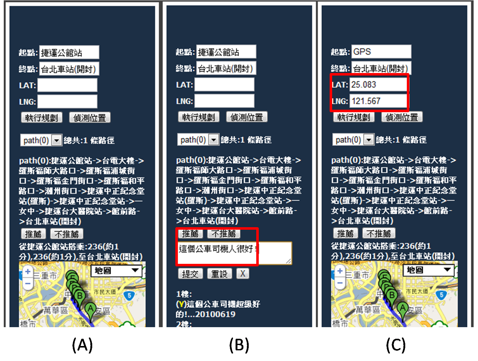
By giving the topology, start, destination bus stops and the modified shorest-path algorithm, we can find a set of bus-pathes and corresponding bus numbers that the user can take them to the destination, as shown in Figure 1. For example, the trip of user A is start from "捷運公館站" to "台北車站(開封)", the system recommends the bus number and arrival time that user A should take into consideration. Besides, our system also supports the GPS that the start bus-stop can be automatically detected by nearest bus-stop based on the user current GPS location.
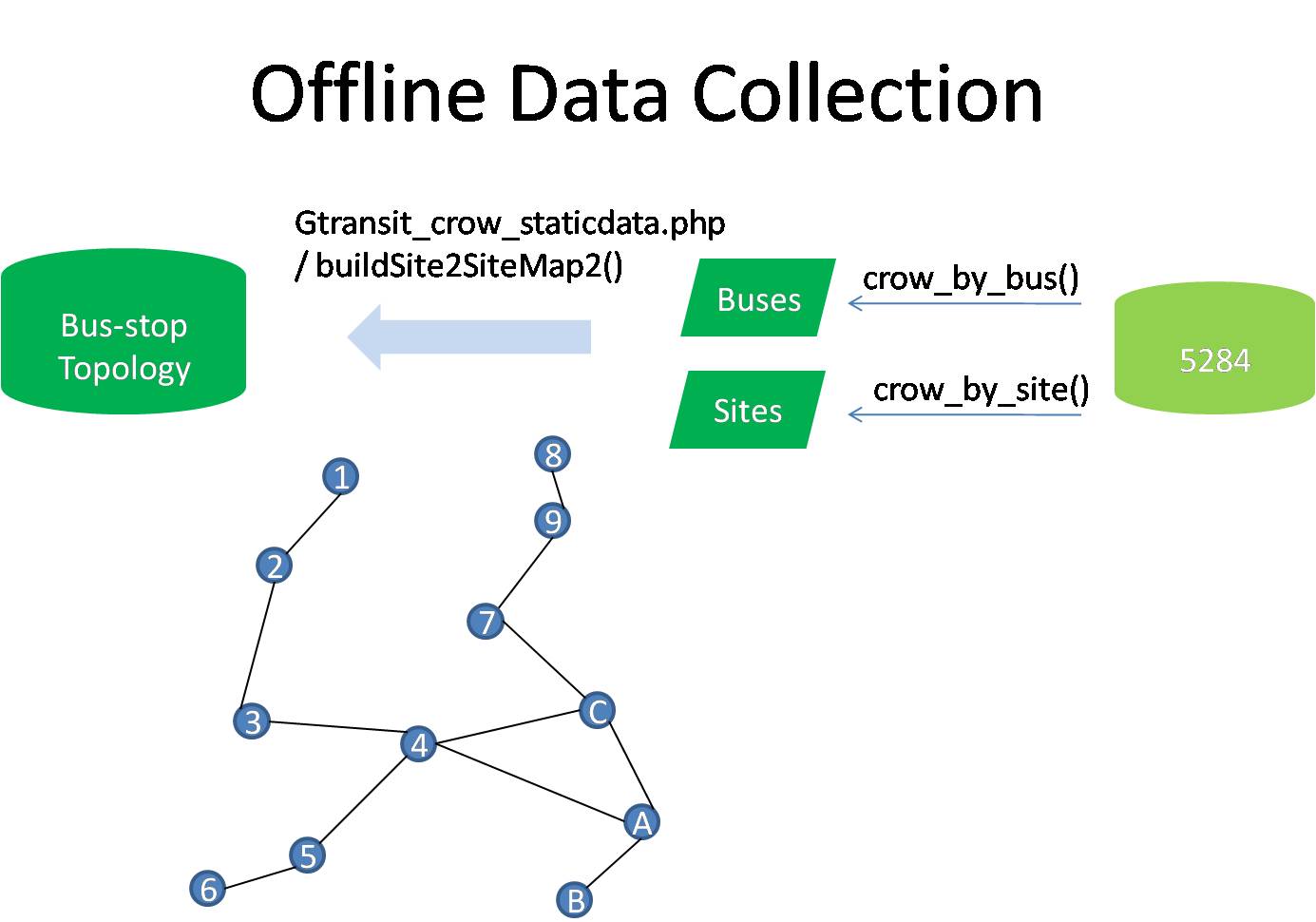
 In ODC, we collect the bus and stop information from 5284[1] by the functions (crow_by_bus and crow_by_site).
From these two functions, we can obtain two information: 1. The path of each bus, the path is consisted of a set of bus-stops. 2. The arrival time of each crossed site buses.
Based on these two information, we can construnct taipei-city bus-stop topology G that the bus-stop is denoted as vertice in G and the edge between two vertices is determined the path of buses.
For example, we have three buses B1, B2 and B3 with the path {1 -> 2 -> 3 ->4 -> A->B}, {8->9->7->C->A} and {C->4->5->6}, respectively.
The topology based on these three buses can be constructed as shown in Figure 2.
In ODC, we collect the bus and stop information from 5284[1] by the functions (crow_by_bus and crow_by_site).
From these two functions, we can obtain two information: 1. The path of each bus, the path is consisted of a set of bus-stops. 2. The arrival time of each crossed site buses.
Based on these two information, we can construnct taipei-city bus-stop topology G that the bus-stop is denoted as vertice in G and the edge between two vertices is determined the path of buses.
For example, we have three buses B1, B2 and B3 with the path {1 -> 2 -> 3 ->4 -> A->B}, {8->9->7->C->A} and {C->4->5->6}, respectively.
The topology based on these three buses can be constructed as shown in Figure 2.
 As shown in Figure 3, when the start and destination bus-stop are defined by the user, by giving a distance-cost threshold and the generated topology, we can find all pathes which distance costs are below the threshold. The distance-cost is determined by the number of bus-stop from the start to destination bus-stops. The found pathes, however, lack the bus-based concept that the user have no idea how to reach desnition by the recommended pathes. Based on this point, the bus pathes collected from 5284 are used as path filter to transfor the generated pathes into get the bus number, arrival time and the bus-exchange information. Finally, the system ranks the pathes by the arrival time and recommends to the user.
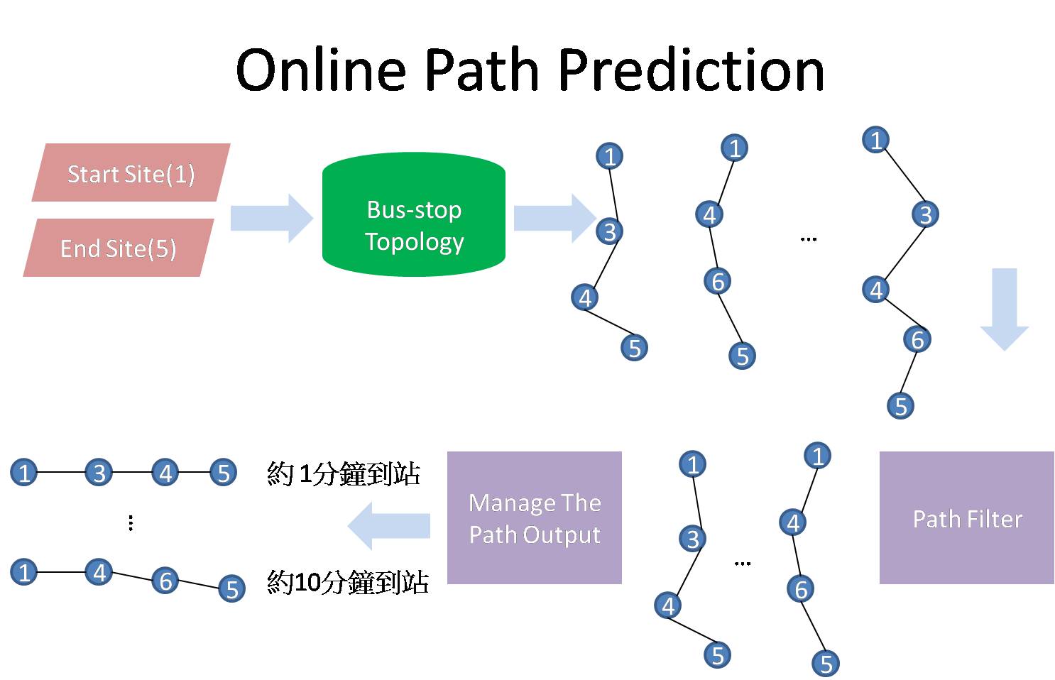
Figure 1. The City Bus Plane Demo
Figure 2. Offline Data Collection
Figure 3. Online Path Prediction
Reference:
[1] 5284 web site. "http://www.taipeibus.taipei.gov.tw/"
[1] 5284 web site. "http://www.taipeibus.taipei.gov.tw/"